Rising threat
PROVIDENCE — Crews from the U.S. Army Corps of Engineers arrived at the Fox Point Hurricane Barrier the night before Superstorm Sandy was due to hit the Northeast in 2012.
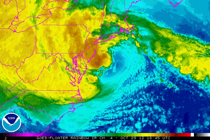
They divided into four-hour shifts, so they could be ready to jump into action around the clock. Sometime between 3 and 4 a.m. on Oct. 29, the charts on their computer screens showed the beginnings of a surge approaching Rhode Island, says Rich Patterson, one of the crew leaders that morning.
Shortly before 7 a.m., with the full-moon tide reaching its peak, he and the other workers closed the barrier’s three towering gates and sealed off the Providence River from the floodwaters to come.
At the height of the storm about an hour later, Patterson stepped outside to a near-surreal contrast in scenes from one side of the barrier to the other.
On the side of the river facing Narragansett Bay, the surge rose 7.6 feet above mean sea level, the wind pushing the water up against the concrete wall and steel gates as waves crashed in and sent spray and foam up toward Patterson, who stood on a walkway above.
And on the side facing downtown Providence, the waters were calm.
“Nobody on the other side of the barrier saw a thing,” Patterson recalls.
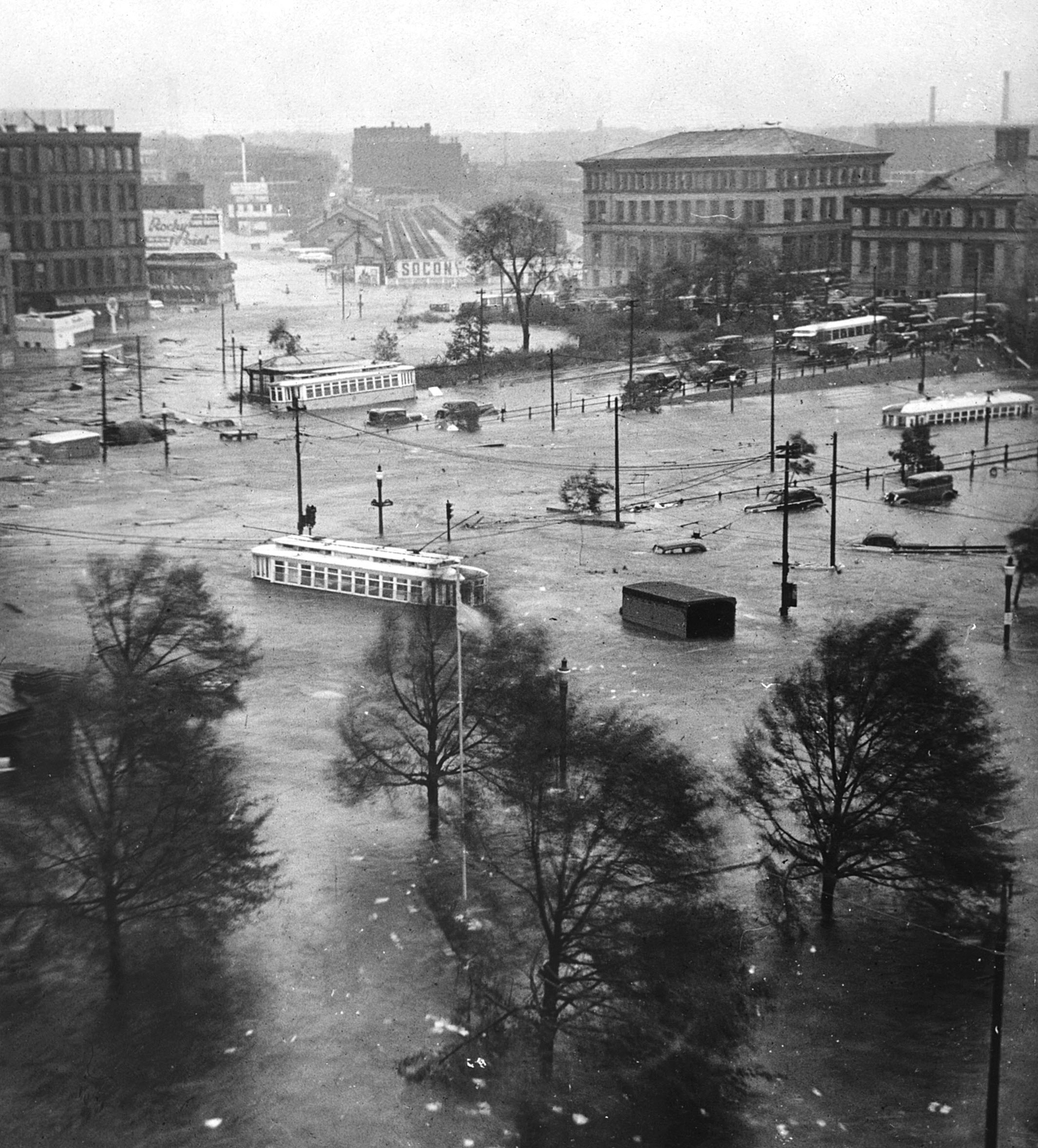
In a sense, the scene that played out on that autumn morning nearly seven years ago tells the story so far of the Fox Point Hurricane Barrier, which has quietly stood guard at the mouth of the Providence River for 53 years, its virtual invisibility proof of its effectiveness.
A groundbreaking project when it was dedicated in 1966, the barrier was the first hurricane-protection structure in the United States.
It was designed to withstand a surge of up to 20.5 feet from a 500-year storm, or one with a 0.2 percent chance of happening in any year — a conservative design at the time, says Malcolm Spaulding, emeritus professor of ocean engineering at the University of Rhode Island. To put that number in perspective, the surge from the Hurricane of 1938, the largest confirmed on record in Rhode Island, was about 15.8 feet.
Seas in Providence have risen about 5 inches since the barrier’s completion and nearly a foot since 1900. The rate of sea-level rise — which is higher in the Northeast than almost anywhere else in the world and is expected to continue to outpace the global average — is accelerating as waters heat and expand, ocean currents slow and glaciers melt.
With seas that are 5 feet higher, which is possible within the next four to five decades, a 500-year storm of today will become a 100-year storm of tomorrow, or one that has a 1 percent chance of happening in any year. That may not seem a like a big change, but it amounts to a fivefold increase in the likelihood of a devastating surge occurring.
“So, not so conservative anymore,” Spaulding says of the barrier's design.
Despite mounting evidence about the threats of climate change, the Army Corps of Engineers has never done a study of the impacts of sea-level rise on the Fox Point barrier or similar structures under its care.
The stakes are high for Providence. The barrier protects 280 acres of downtown, property that the city estimates is worth $2 billion and includes South Street Landing, the Wexford Innovation Center and other new projects that have been built near the water.
Yet there are questions about the barrier that remain to be definitively answered: at what point could seas rise high enough to make the barrier obsolete? Will the wing walls maintained by the City of Providence on either side remain effective for as long as the main structure? Do the pumps connected to the barrier have enough capacity to prevent flooding if a storm surge is accompanied by extreme rainfall? Where will the barrier get its power if a storm knocks down the electric grid?
U.S. Sen. Sheldon Whitehouse, perhaps the leading voice on climate change in Congress, has repeatedly called for a new assessment of the barrier to answer these and other questions.
“Getting started now is important, so that we’re not looking back with regret at something we anticipated but failed to prepare for,” the Rhode Island Democrat says.
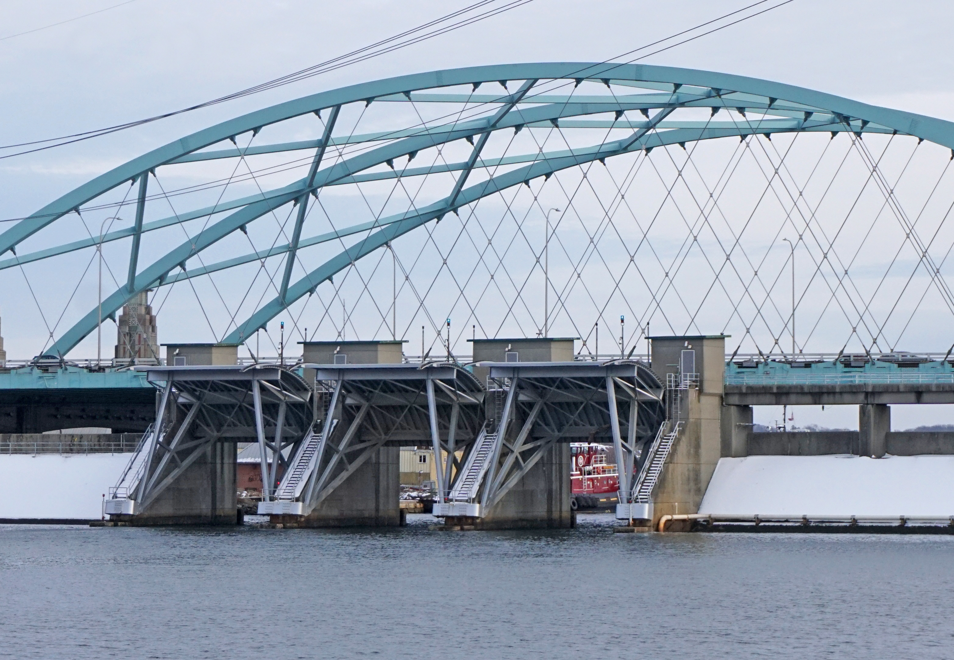
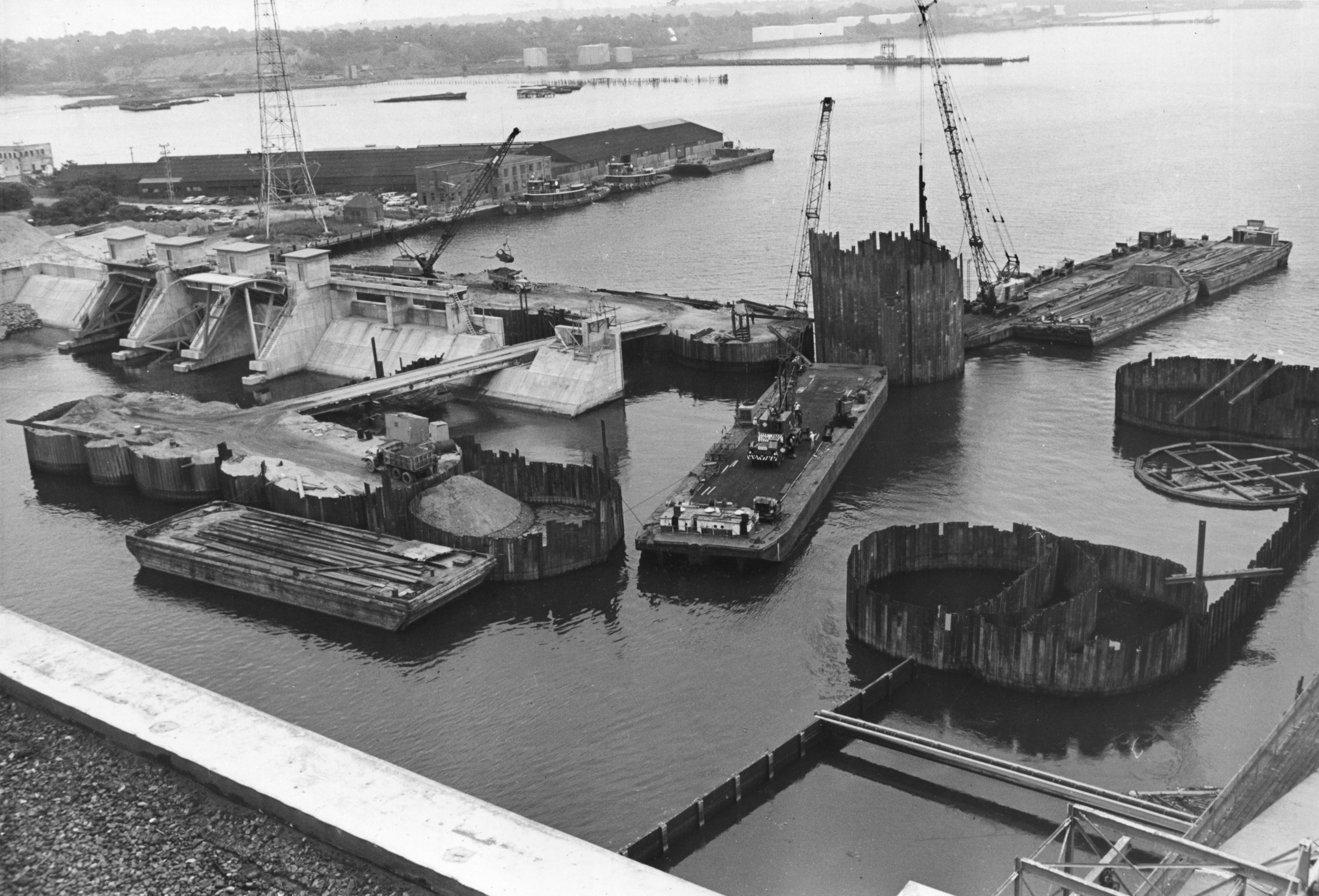
Built by the Army Corps and maintained for most of its life by the City of Providence, the barrier is more than a single structure.
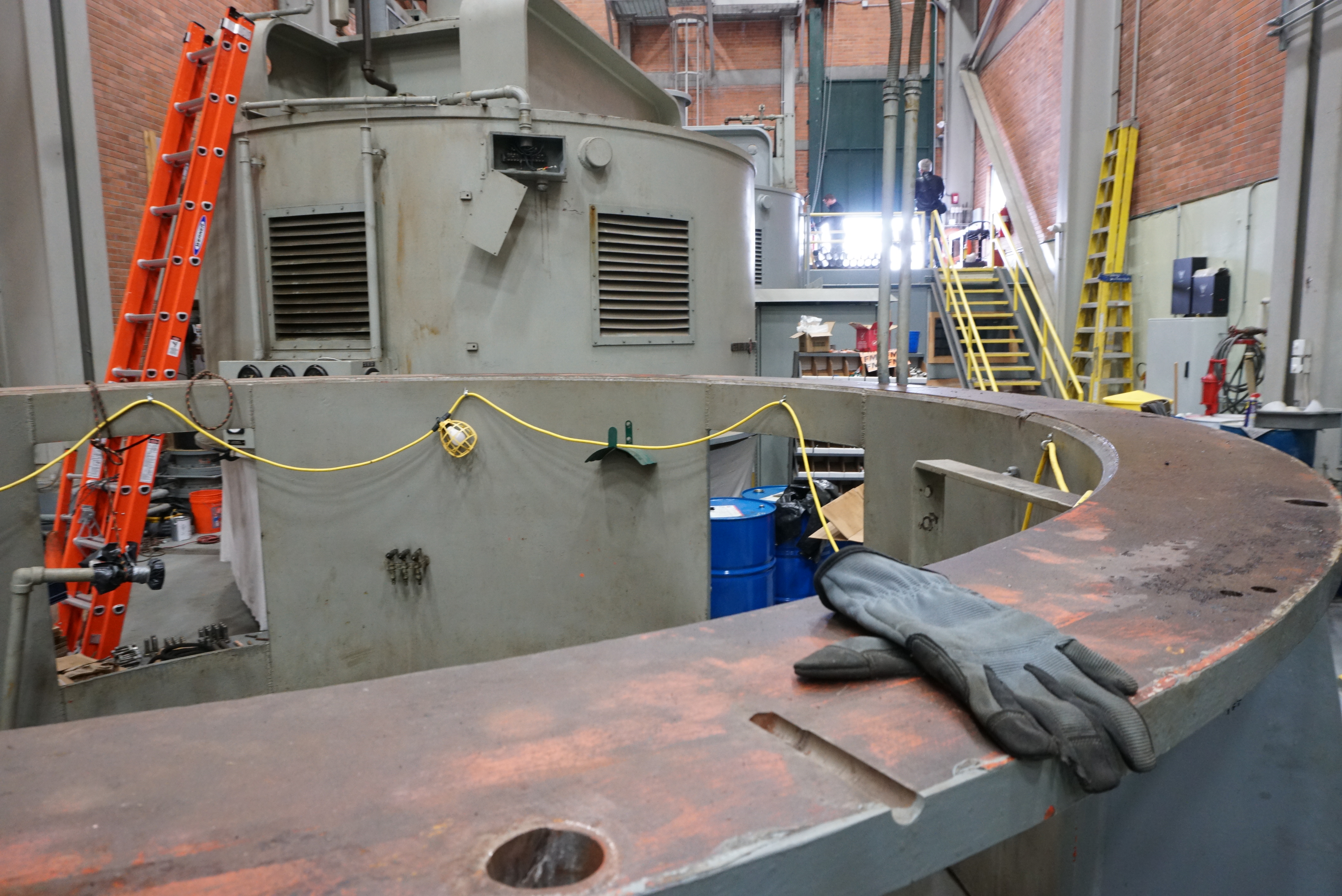
There is the central dam standing 25 feet tall and extending 700 feet across the river that on its east end has three convex Tainter gates — named for the engineer who came up with the design. Each gate measures 40 feet high by 40 feet wide and weighs 53 tons.
They stand open above the river, allowing boats to pass through but ready, when seas reach about 4.6 feet high, to be rotated down on radial arms. It takes 45 minutes to lower them and twice as long to pull them back up again.
Flanking each side of the barrier are retaining walls and dikes that extend 780 feet to the east, toward India Point Park, and 1,400 feet to the west, along Allens Avenue. In five places where roads cut through them are gates that can be closed. Underground, there are another five gates to prevent water from backing up in the sewer system.
Inside a building on the west end of the barrier are five massive centrifugal pumps that Corps engineers at the time of construction heralded as the most powerful in the world. When the gates are closed, the pumps send water to the Bay side of the barrier, preventing the river on the city side from overflowing its banks. Each can move 630,000 gallons a minute — nearly the amount in an Olympic-size swimming pool.
It took almost 20 years for the barrier to face its first test, but on Sept. 27, 1985, it did its job, keeping out Hurricane Gloria’s relatively moderate surge. The barrier did it again on Aug. 19, 1991, when Hurricane Bob’s slightly higher surge threatened Providence.
But the city failed to keep up on repairs, and just five years after Bob, John J. Partridge, the Providence lawyer who chaired a city commission on the barrier, described the facility as being “virtually inoperable.”
“... only one pump was workable,” he wrote in The Journal. “The gates could not be easily closed or, if closed, were difficult or impossible to open.”
After Hurricane Katrina in 2005, the Army Corps reviewed flood-control structures around the nation. As a result, the agency worked out an agreement with Providence to take over operation of the barrier, while leaving responsibility for the wing walls in the hands of the city.
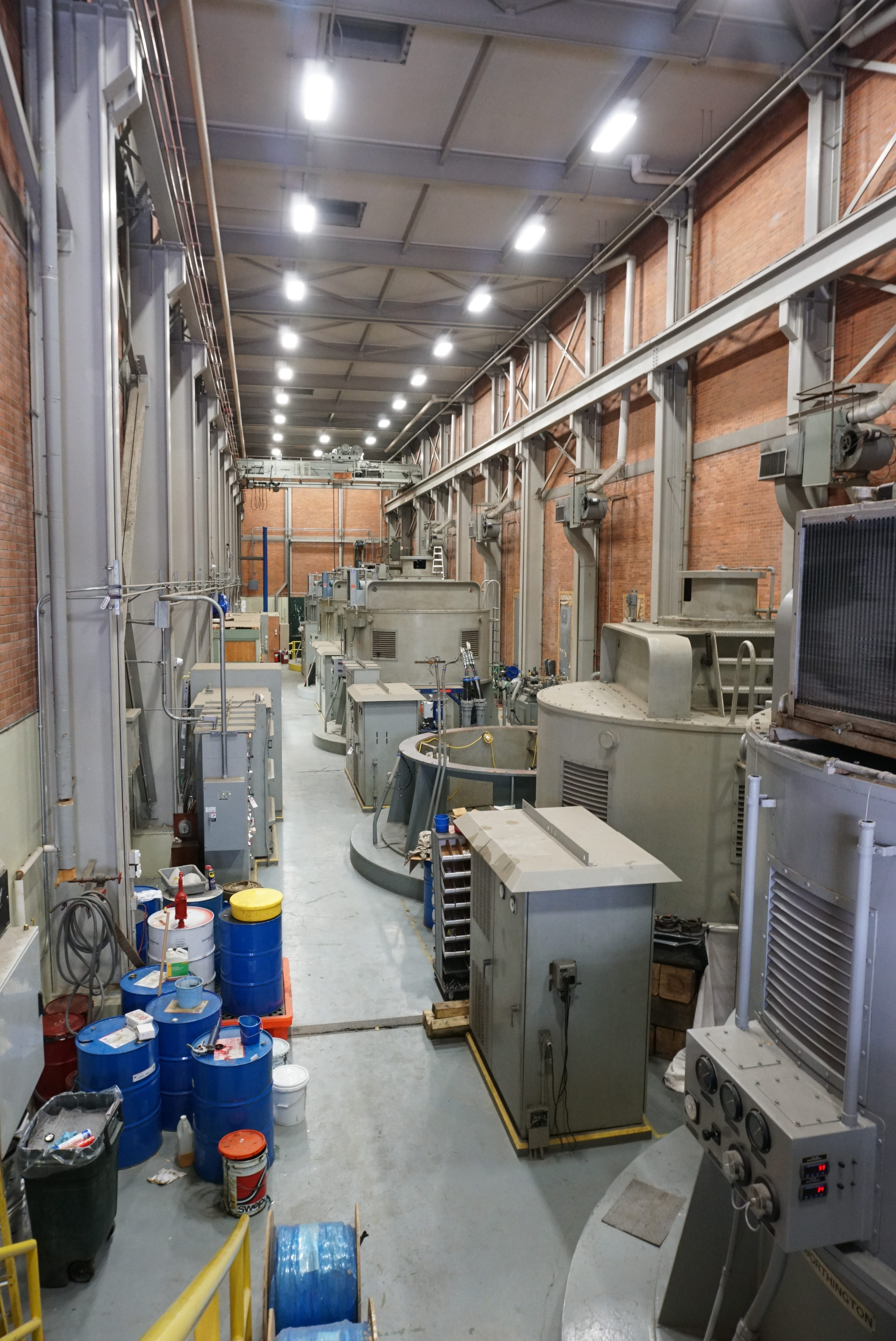
Since the transfer in 2010, the Corps has spent about $20 million to revamp the facility. About three years ago, it replaced all of the 1960s-era wiring with modern electrical controls. It fixed one of the pumps, which had broken down, and rehabbed three others. The fifth is in the midst of repairs.
Portions of the wing walls are also new, having been rebuilt as part of the relocation of Route 195, and, based on annual tests carried out by the city, the street and sewer gates are still able to do their job.
“I think there’s a strong level of confidence that those barriers are in good shape,” says city engineer William Bombard.
It’s not the level of maintenance, though, that worries observers anymore, but how the original design has held up in changing conditions.
Climate change isn’t just causing seas to rise. It is increasing the incidence of severe hurricanes and, in the Northeast, the frequency of extreme rainfall events. It is also making storms more damaging by slowing them down and allowing them to stall in place. Think of Hurricane Harvey two years ago, or Hurricane Florence last year.
The Rhode Island shoreline has also changed, as development has encroached into marshes and tidal flats that would normally soak up some floodwaters. The filled land along the Bay could force a surge into a narrower channel, raising its height as it moves toward the barrier. And urbanization along the rivers that flow into the Bay exacerbates storm runoff.
“All of it adds up to an equation in which the waters come in faster and higher,” says Bryan Oakley, assistant professor of environmental geoscience at Eastern Connecticut State University.
Spaulding, the URI ocean engineer and an adviser to the state on sea-level rise and other impacts of climate change, last year co-directed a study of the hurricane barrier by senior engineering students from the university. They concluded in their 94-page report that an original portion of the dike on Allens Avenue may be the most vulnerable part of the system.
The 10- to 15-foot-high dike consists of an earthen core with sloping sides, the Bay side armored with large boulders and the city side faced with smaller stones. It has settled by up to 1.3 feet in places over time, the students found.
If a surge were to overtop the main concrete barrier, it would simply spill over the edge, like water pouring over the rim of a glass. It may cause flooding but wouldn’t compromise the barrier’s stability. But if the same thing happened to the dike, the force of the water rushing over the top and down the slope on the city side could wash away the stone facing and work into the earthen core.
“It chews that away, and then it breaches,” Spaulding says.
With 5 feet of sea-level rise, the integrity of the dike could be undermined in the event of a large storm surge. With 7 feet, a surge could destroy it.
It’s also with 7 feet — which is projected this century even under moderate sea-level rise scenarios — that the barrier would no longer offer protection from a 100-year storm, according to the study.
But could something go wrong now?
Conceivably, if the barrier were to lose power.
Two high-voltage lines feed power to the facility directly from the nearby Franklin Square substation owned by utility National Grid. Both were replaced about four years ago and each can supply the barrier on its own. The substation is supplied by an overhead transmission line and two underground feeder lines from the new South Street substation on Eddy Street. A spokesman for National Grid described an outage to the barrier "a low-probability event."
"All this being said, without ever knowing how severe an impact Mother Nature could send our way until it actually arrives, we could never guarantee an indestructible system — we can only aim to have the redundancies in place to help prevent against such an incident," Ted Kresse said.
There is a backup generator for the gates and electrical controls, but, Spaulding points out, it sits outside the barrier’s pumphouse at ground level and appears vulnerable to flooding.
As for the pumps, they use so much electricity that before they go into operation, the Corps must notify National Grid to ensure that the rest of the system has enough supply. And that level of usage makes it impossible for them to have a backup source of power. Generators simply wouldn’t be able to do the job. For context, each pump has a 4,500-horsepower motor. A household sump pump may have a capacity of only one-third of a horsepower.
“If the grid goes down, the pumps go down. And the question is, what do they do then?” says Grover Fugate, executive director of the Rhode Island Coastal Resources Management Council.
The URI students combined elements of historical floods to create a hypothetical extreme rainstorm accompanied by a surge — an unlikely event, they concede — and found that with the barrier closed, more than 200 buildings downtown would sustain some flooding, even with the pumps operating. If the pumps go down, four times as many buildings would be affected.
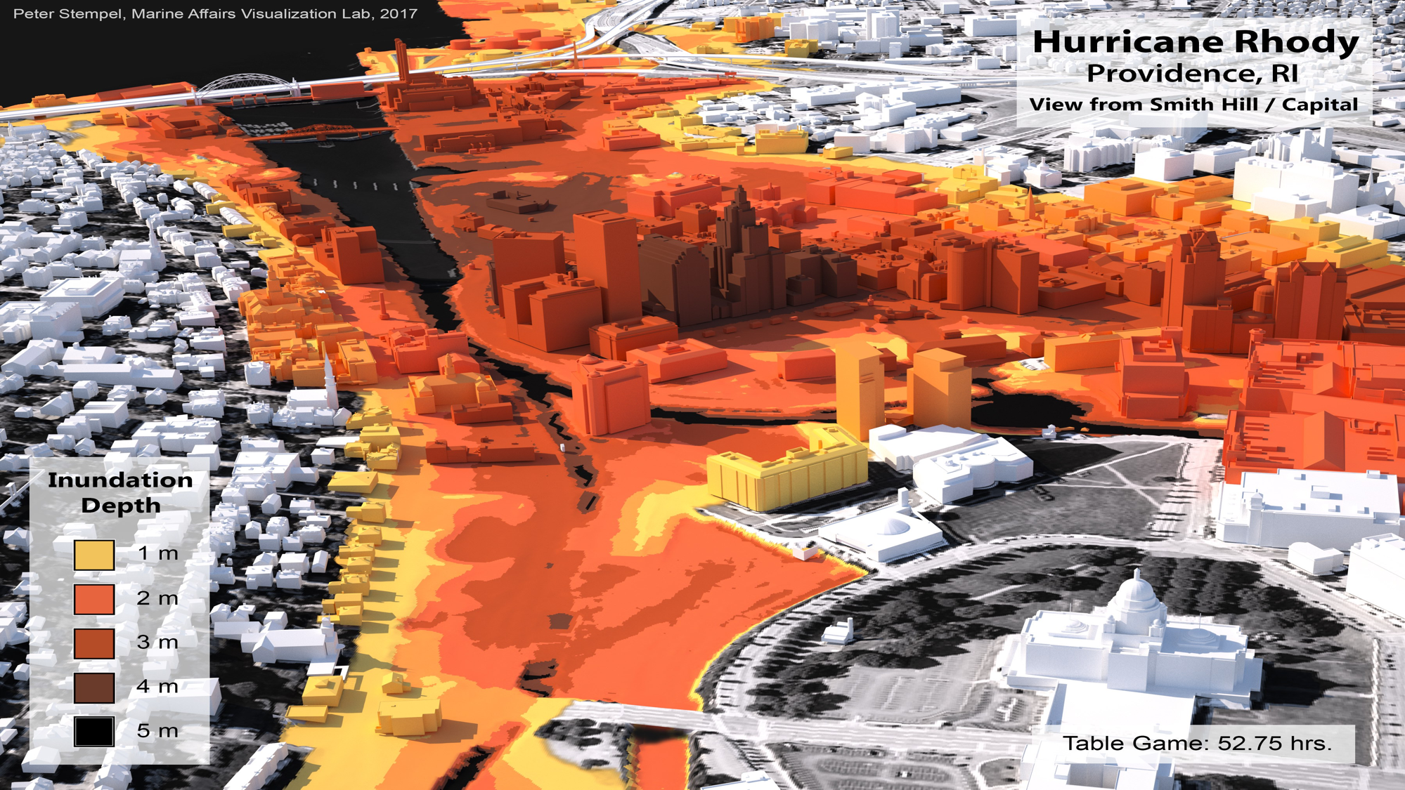
A power outage is also built into what could be the worst-case scenario facing Providence. Designed by URI hurricane expert Isaac Ginis as part of a Department of Homeland Security-funded project, “Hurricane Rhody” combines elements of the most powerful storms to ever hit the city.
Rhody would follow Hurricane Carol’s track, have a rapid forward speed close to the Hurricane of 1938, and would abruptly slow down and make a second landfall like Hurricane Esther in 1961. Winds would top 70 miles per hour. Rainfall would exceed 20 inches.
In one simulation of the storm, the barrier’s gates would be closed to fend off Rhody’s surge, but high winds would then knock down the power grid. If the barrier’s generator fails, it would make it impossible to raise the gates again in time for the storm’s saturating second pass.
The Woonasquatucket and Moshassuck rivers, which converge to form the Providence River, are both shallow, narrow and relatively short, so they would fill up fast and, with the barrier closed, would overspill their banks and flood the city. The waters would reach up to 10 feet high in Kennedy Plaza and even higher around South Street Landing.
In another simulation that ratcheted Rhody up to a Category 5 hurricane — a type of exceedingly powerful storm that has rarely made landfall in the United States — the surge would rise 23 feet and spill over the barrier.
Ginis, a professor of oceanography, says that Harvey and Sandy, which was also a big, slow-moving weather system, demonstrate how coastal storms are behaving in ways that would never have been considered in the past.
“My view is that we just need to look at all the physically plausible scenarios when we think of coastal resilience and protection of coastal areas,” he says. “These are things that we need to be prepared for.”
Last October, President Donald Trump signed into law America’s Water Infrastructure Act.
The act included a provision written by Whitehouse that requires the Army Corps to study the resilience of its hurricane barriers in the Northeast.
A report, due within one year of the law’s enactment, must give “particular consideration as to how such barriers and harbors will survive and fully serve their planned levels of protection under current, near, and longer term future predicted sea levels, storm surges, and storm strengths,” the act says.
A week after the signing, Whitehouse led R.D. James, the head of the Corps, on a tour of coastal infrastructure in Rhode Island that included the Fox Point barrier in an effort to emphasize the importance of a study. He followed up with a letter last month.
The Corps, however, has yet to start anything. In response to questions from The Journal, a spokesman said the agency would need a specific appropriation from Congress to carry it out.
“To begin such a study the Corps would need funding with a new start designation,” Timothy Dugan, spokesman for the Corps’ New England District, wrote in an email. “We have yet to receive any funding for the effort, so it has not begun. There are a number of other studies the Corps is awaiting funding for, which were authorized prior to this one. We don't have a timeline when this study will begin.”
Whitehouse, a member of the Senate Environment and Public Works Committee, says the agency has discretion to conduct the study if it so chooses.
“It’s not a matter of them not having the money,” he says. “We shovel enormous amounts of money into the Army Corps. It’s a matter of trying to assert our priorities.”
Asked if he believes the Trump administration’s views on climate change may be interfering with a study, the senator said he doesn’t think so.
Two years ago, the City of Providence hired consultants and gathered stakeholders to consider the future of the barrier. In a subsequent report, they projected that it would be able to continue to protect downtown for at least another 50 years and recommended holding off on any decisions until 2050.
The group’s work, led by a climate finance expert from Johns Hopkins University and the nonprofit Center for Climate and Energy Solutions, is not an engineering study. A city spokesman described it as a “big-picture report.”
Whitehouse, whose staff participated in the discussion sessions, says the city’s work does not replace a study by the Army Corps. Even if the Corps were to come to a similar conclusion as the city, more detailed research is necessary to prepare for the future, the senator says.
Spaulding, who has served on panels advising the Corps, recommends more study of the wing walls at the very least.
Fugate and other staff at the Rhode Island coastal council have also urged the Corps’s New England office to move forward with an assessment.
“They said they would form a working group, but that was a year or two ago,” Fugate says. “We keep trying to talk to them about it.”
It’s geography that makes downtown Providence vulnerable to flooding.
The area was once a cove deep enough for sailing ships. The Great Salt Cove covered hundreds of acres and stretched north to a sandy bluff where the State House now sits. The marsh-lined Woonasquatucket wound its way into the cove from the west and the Moshassuck fed it from the north.
South of what was then Weybosset peninsula was Providence Harbor and, beyond that, the Great Salt River, now the Providence River. The west side of the harbor where Manchester Street Station and one side of the hurricane barrier now stand is all filled land. And so is the land north of the peninsula that became the city’s financial district.
But even as the cove and the marshes have been filled and the rivers have been channeled, water still wants to go where it always has.
There will come a time when seas rise high enough to flood downtown. It will start with more frequent “sunny-day” or nuisance flooding, events that are already occurring when unusually high tides on top of higher seas periodically push waters into places like Waterplace Park.
Projections from STORMTOOLS, the online program developed by URI and the CRMC, show that downtown Providence will be able to withstand up to 3 feet of sea-level rise with minimal impacts. But any higher and the effects multiply, with extensive flooding especially on the west bank of the Providence River.
That was the side that saw the most extensive in-filling. It’s also an area of the city with large blocks of land freed up by moving Route 195 and now targeted for development. The Fane Tower project is proposed there.
By 2100, downtown Providence would flood twice a day, according to the projections.
The Army Corps already closes the barrier 10 times a year on average for moon or king tides, more often, the agency says, than when the city was responsible for the facility.
There may be a period when Providence can ease the effects of tidal flooding by stepping up use of the barrier, but the structure wasn’t designed to be closed on a daily basis and it’s expensive to operate — the city says it costs $2,500 every time the gates and pumps are used, though the Army Corps could not confirm that figure.
In the longer term, protecting Providence may require more than just a hurricane barrier. It may mean the construction of permanent seawalls or levees, or it could mean adapting buildings to periodic flooding.
Despite the gloomy predictions, Providence is in a better position than other Rhode Island cities and towns that lack any sort of flood protection. For low-lying coastal communities like Barrington, Warwick or Newport — which are among the most vulnerable in Rhode Island to rising seas — some level of flooding is inevitable. It may also be impossible to protect them from higher storm surges, unless a 1950s-era plan for hurricane walls across the mouth of Narragansett Bay (see related story) is dusted off.
Enhancing the protections for Providence may also be easier than in any other places in the Northeast because large portions of the city sit at higher elevations and because the Providence River, even south of Fox Point, is relatively narrow.
The Providence report estimated the cost of raising the hurricane barrier by 3 feet to be $150 million, and by 6 feet to be $200 million. A 40-foot-high structure at Fields Point modeled on the Maeslantkering, storm gates that protect Rotterdam in Holland, would cost close to $1 billion.
In contrast, a study released last year estimated the cost of building barriers to protect Boston Harbor at up to $11.8 billion. Systems to protect New York City could be three times that amount, according to an Army Corps report.
The Fox Point barrier buys Providence time that those cities may not have, says Leah Bamberger, the city’s director of sustainability. She believes that Providence should start having discussions over the fate of the barrier in the next decade.
“The projections will be more certain at that time,” she says. “This is a conversation that involves a lot of stakeholders and a nuanced understanding of the challenge.”
On a recent morning outside the control room of the Fox Point Hurricane Barrier, Patterson shows off pieces of the pump that is being overhauled.
The long drive shaft sits on a ledge, its bearing, taller than a man, stands below.
The pumps may not be the top of the line anymore, but they are workhorses that have never been used to full capacity. Neither has the barrier itself. The last Category 3 hurricane to hit Rhode Island was Carol. The surges from Sandy and all the hurricanes that have hit Rhode Island since then were each at least 5 feet lower.
Patterson shakes his head emphatically when asked if he’s worried about the barrier holding up in a hurricane. Sandy, which the Army Corps estimates would have caused about $600,000 in flooding damage in Providence, is just one recent example of its effectiveness.
If the barrier had been in place, it would have stopped the surge from the Hurricane of 1938, Patterson says. There are so many variables that affect a surge — wind direction, tides, the path of the storm — that would all have to come together in the worst possible way to truly threaten the barrier.
“It would have to be the ultimate of ultimates,” he says.
As to questions about the future, Patterson and Joe Mazzola, an Army Corps manager, demur.
“For right now, this is what we’ve got,” Mazzola says.
— akuffner@providencejournal.com
(401) 277-7457
On Twitter: @KuffnerAlex
Wall across Narragansett Bay among prior flood-control ideas
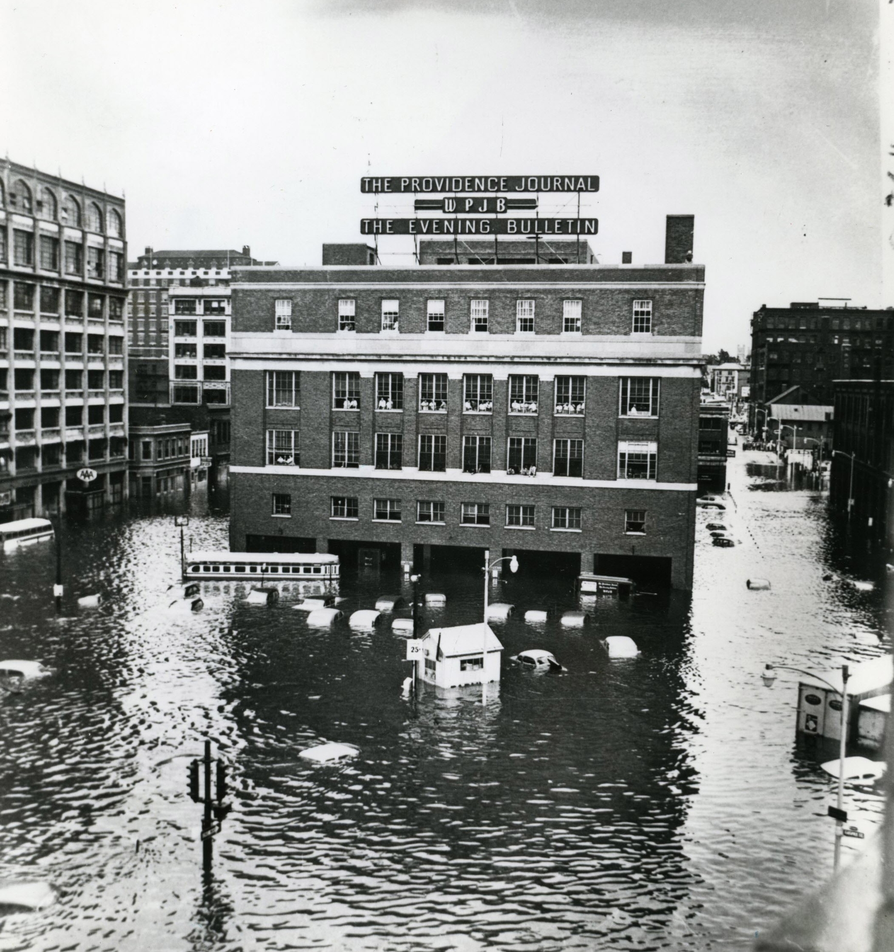
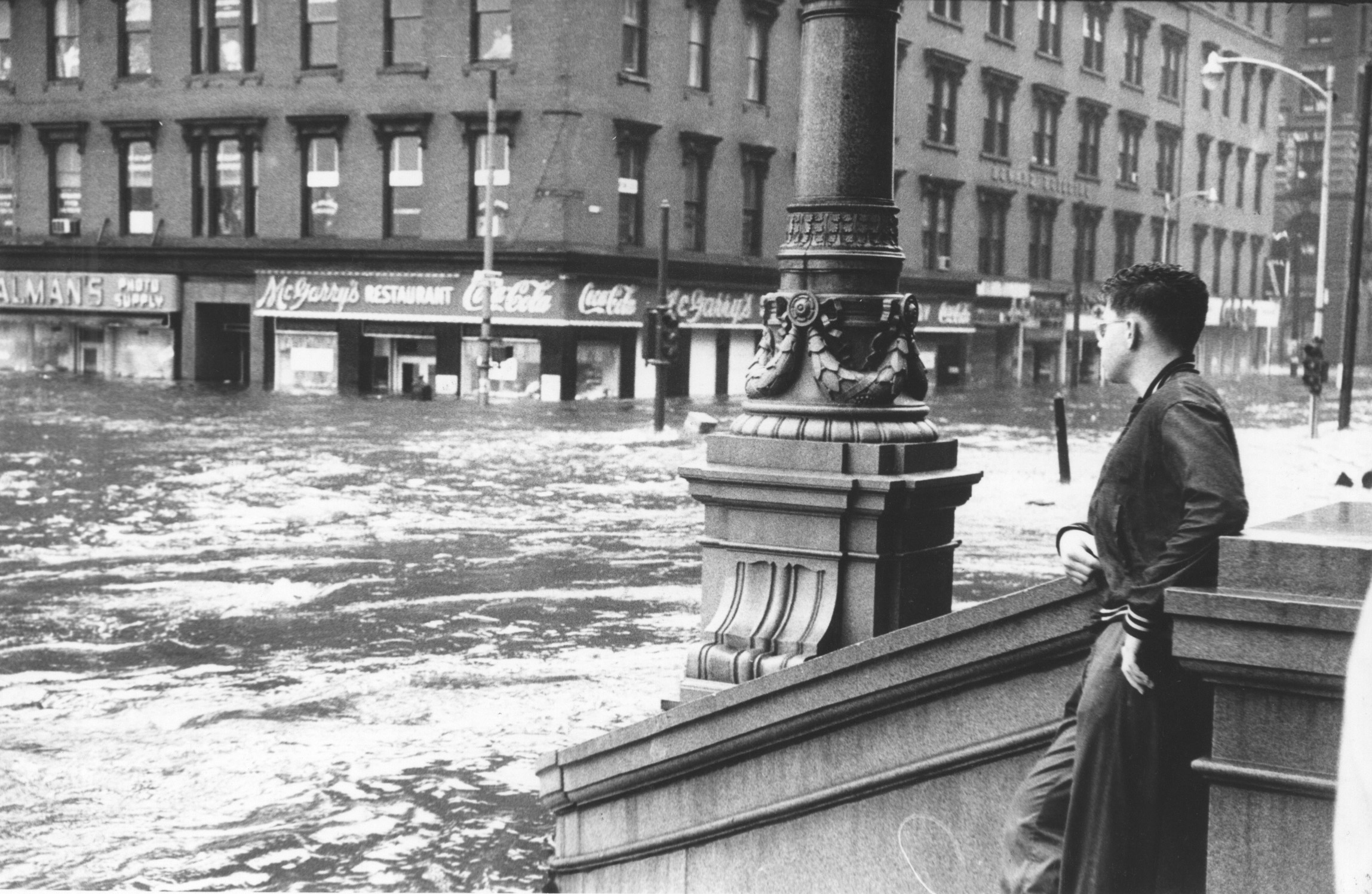
PROVIDENCE — On Aug. 31, 1954, Hurricane Carol barreled into Providence with little warning, arriving at high tide and bringing with it a 14.7-foot storm surge, a bulge of water caused by high winds and low pressure, that swept through the city and inundated the downtown.
It was the third major storm to hit Providence in 16 years, following the Hurricane of 1938 with its record-setting surge and the Hurricane of 1944, which had a surge of 9.9 feet but caused only minimal flooding because it arrived on a low tide. There were earlier hurricane-caused floods in Providence, too, most notably in 1815 and 1869, and there is historical evidence of storm surges that may have topped 17 feet in 1635 and 18 feet in 1638.
It wasn’t long after the floodwaters from Carol receded that Congress ordered the U.S. Army Corps of Engineers to survey hurricane damage in the Northeast and come up with a plan to prevent a similar catastrophe from happening again. The Corps looked at proposals throughout the region, and protecting Narragansett Bay rose to the top of its list.
A research team built a scale model of the Bay that covered a third of an acre inside an aircraft hangar at a facility in Vicksburg, Mississippi, where engineers and scientists tested possibilities for protecting Rhode Island from storm surges and assessed the impacts on the environment.
The most ambitious was a series of massive stone walls across the mouth of the Bay and the Sakonnet River, from Narragansett to Jamestown, Jamestown to Newport, and then Portsmouth to Tiverton. The barriers would have openings large enough for ships to pass through but small enough to block most of the water from a surge.
The sprawling plan was estimated to cost $90 million, or $765 million when adjusted for inflation, and though it remained on the table for years afterward, it was eventually killed in the face of concerns about pollution, navigation and the general health of the Bay.
The researchers also considered building walls between Fields Point in Providence and Kettle Point in East Providence that could be pulled closed by tugboats in advance of a storm surge. And they looked at enclosing Providence’s rivers in conduits and filling in the land surrounding them.
But those plans were dropped in favor of a barrier across the Providence River, the cheapest and least intrusive of the options and the one that would protect the state’s most valuable real estate.
In 1958, Congress authorized funding for the $15-million project ($128 million today), as well as four other barriers in New England: one each in New London, Pawcatuck and Stamford, Connecticut, and another in New Bedford, Massachusetts.
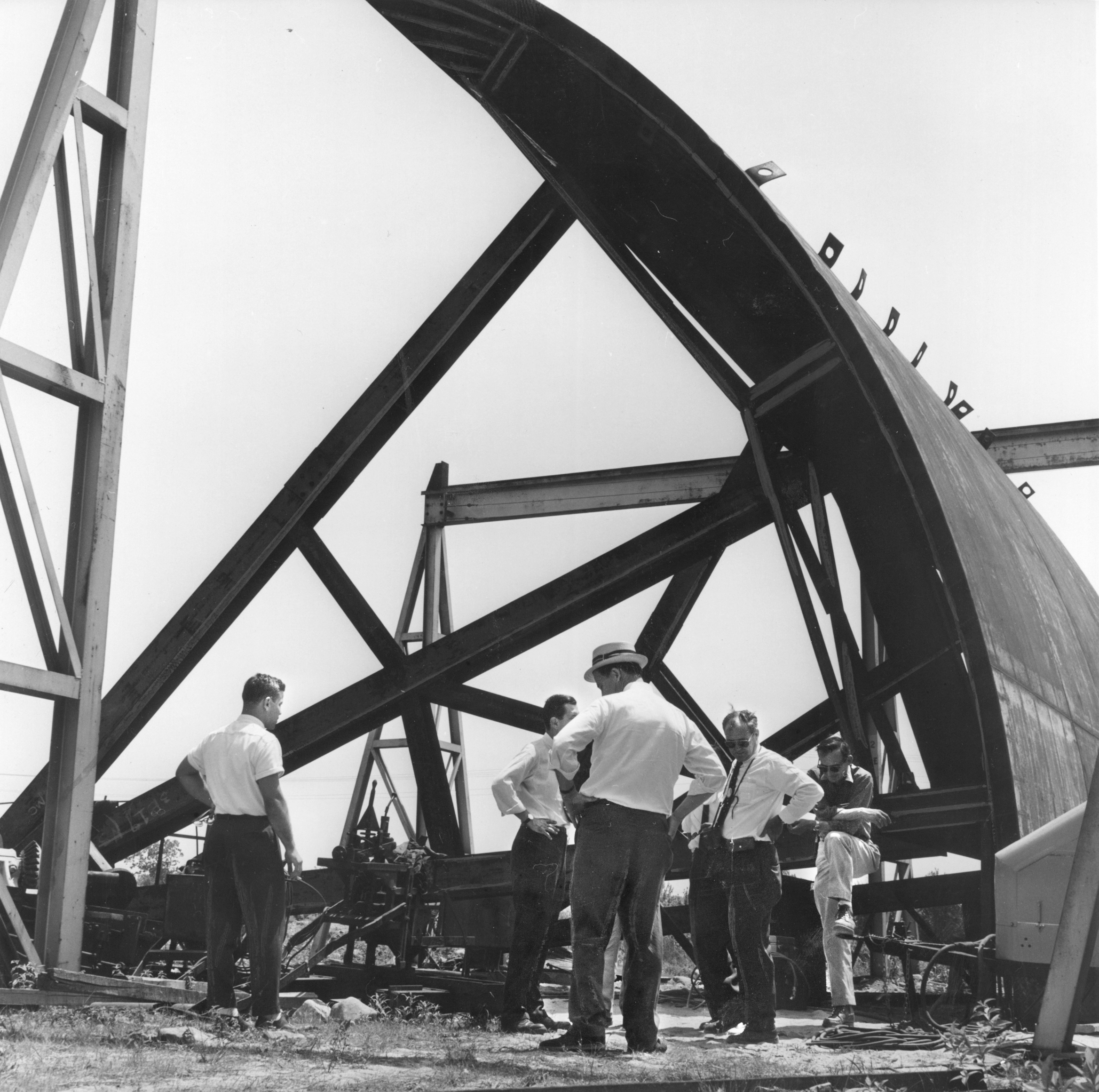
Construction in Providence started in December 1960. The main dam in the river was built within sheet-pile cofferdams that were drained of water. To support the heavy pumphouse and gate structures, workers sank hundreds of piles deep into the river bottom until they hit bedrock.
Work wrapped up in January 1966, and operations were handed over to the city.
“With the completion of the Fox Point barrier, the City of Providence can rest assured that never again will it suffer the devastating damage of 1938 and 1954,” Brig. Gen. Seymour A. Potter Jr., division engineer of the New England Corps of Army Engineers, declared at the groundbreaking ceremony.