Torrential Change
When it rains it will likely pour as climate changes in the region. Climate scientists forecast an increased frequency of heavy rainstorms that will cause flooding in many areas across the region. City and town officials are starting the process of identifying those areas and developing action plans for infrastructure resiliency, flood mitigation and reducing carbon gas emissions.
MetroWest and Milford area cities and towns prepare for coming floods
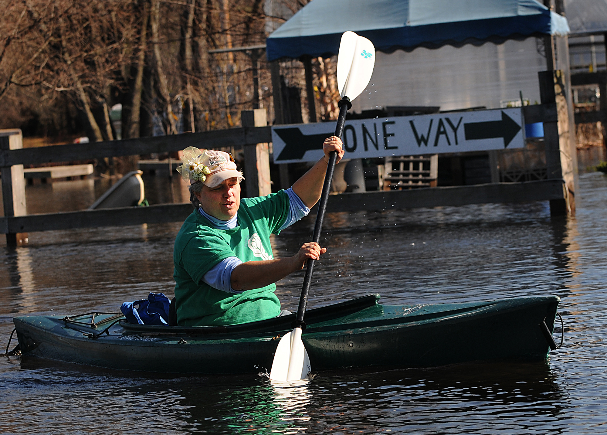
Christina Lamkin firmly gripped a paddle as she maneuvered through the water.
Sitting upright in a forest green kayak, she moved along making left and right turns.
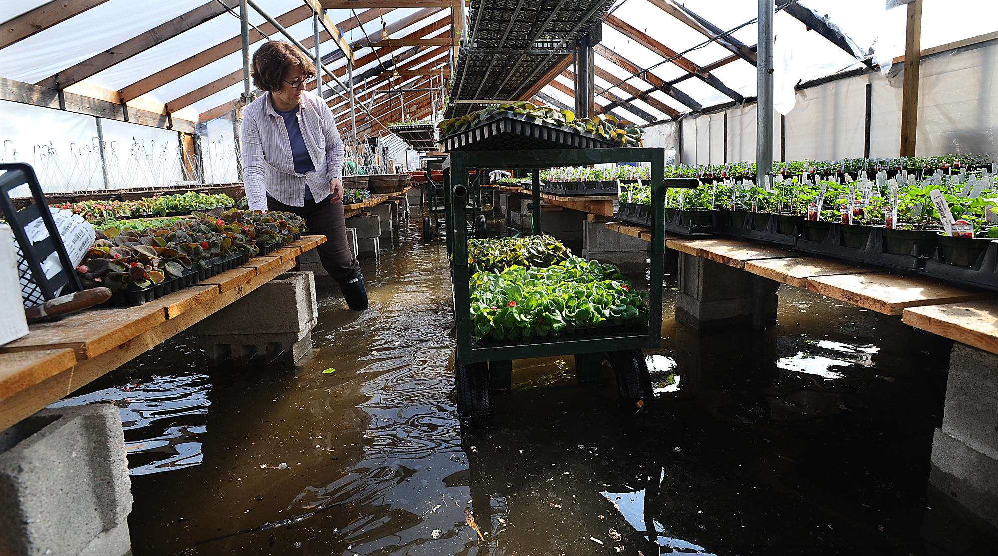
Lamkin wasn’t in the Great Meadows Wildlife Refuge enjoying the beauty of nature. She was navigating her way around the Russell Garden Center parking lot in Wayland, which was under several inches of water.
That was in March 2010, during one of the wettest periods in state history. More than 17 inches of rain fell between March 13 and March 31, according to the Blue Hill Observatory Science Center in Milton. It was a stark contrast to the typical 3 to 4 inches of monthly rainfall across the state, according to the state’s environmental website, resilientma.org
“We were just having fun goofing around,” said Lamkin, a garden center employee. “But for the store, it was very difficult. It got soaked.”
Anyone who has lived in Wayland for more than 30 years will tell you the town floods at least once every 10 years - in large part due to an abundance of wetlands and its watershed. But town officials worry that a climatologist’s forecast for the increased frequency of more intense rainstorms during winter and spring make another 2010 scenario all the more likely.
To get a better understanding of what MetroWest and Greater Milford residents can expect as the climate shifts, the Daily News reviewed several documents - some obtained through public records requests - and interviewed public officials across the region, climate scientists and advocates to find out what the effects of a changing climate will look like and what they are doing to plan for it.
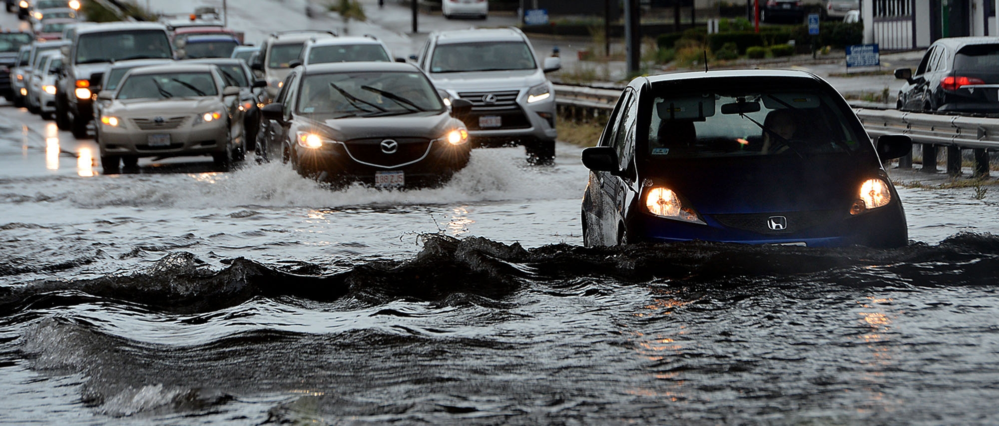
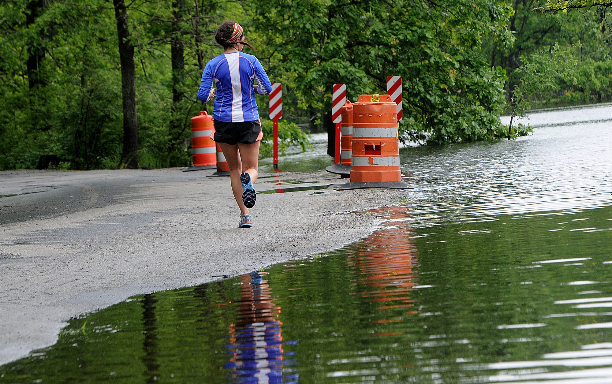
The common thread of response, or resiliency, plans now taking form in local cities and towns is flooding. That is because rainfall is expected to continue to increase significantly in the Northeast over the next century.
The March 2010 deluge ranks as one of the most destructive in Wayland. Damage to the public safety building totaled $1.2 million, the town library needed $130,000 in repairs and other town offices received extensive water damage, said Fire Chief Neil McPherson.
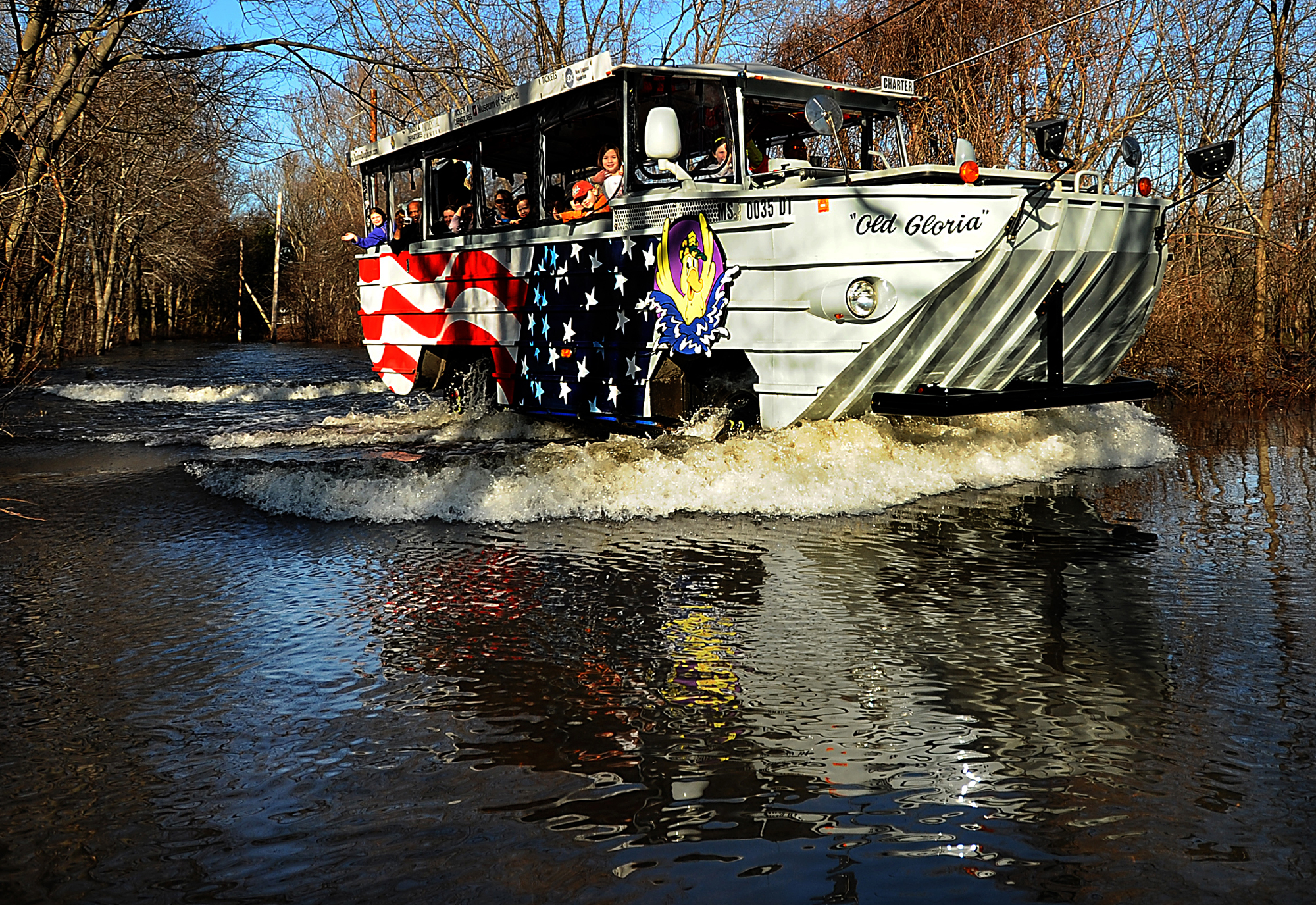
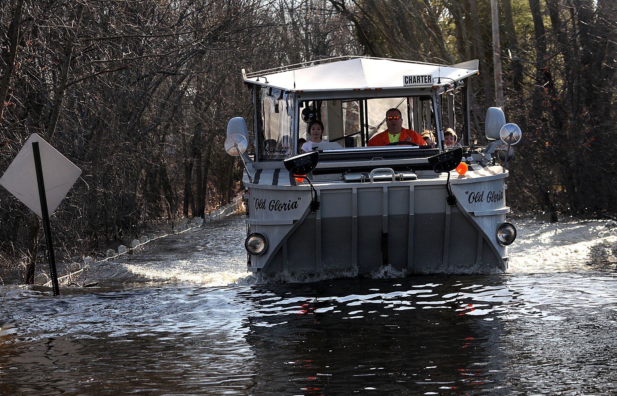
For more than a week, people who lived on Pelham Island Road had to board a duck boat to get out of their neighborhood because the surrounding roads were underwater.
Of the 27,602 federal disaster declarations in the state during March 2010, 91 were taken out by Wayland residents, resulting in more than $137,000 in federal assistance in the town alone, said Dennis W. Pinkham, external affairs director for the U.S. Department of Homeland Security.
‘We’re facing more climate related events’
Taking advantage of the state’s climate change resiliency grant project - the Municipal Vulnerability Preparedness Program - the town recently conducted an $8,000 case study of the 2010 storms to better understand how it should prepare for more extreme weather. McPherson serves as the town’s Municipal Vulnerability Preparedness Program lead. The town also received a $15,000 state grant to develop a plan to address flooding and other problems linked to climate change.
“The reality is that we are facing more and more climate-related events, and the severity of those events seems to be increasing,” McPherson said.
In addition to more frequent intense rainfall, the annual average temperature is expected to increase. In Massachusetts the average annual temperature from 1971 to 2000 was 47.5 degrees Fahrenheit. By the 2050s, forecasters say the average annual temperature will increase between 2.8 to 6.2 degrees Fahrenheit, according to resilientma.org
Winter precipitation in the state could increase annually by between 0.49 and 3.9 inches in coming decades, according to the website. Right now, the average annual rainfall in the state is approximately 48 inches.
Additionally, the number of days “with more than 2 inches of rainfall is expected to increase from less than 1 day per year to approximately 0.9 to 1.5 days by 2100,” according to resilientma.org.
While on the surface, a little more than 2 inches of rain might not seem like a lot, but it quickly adds up, especially in urban areas, said Mathew Barlow, a professor and climate scientist at the University of Massachusetts Lowell.
“My immediate reaction, and I think most people’s, is to imagine 2 inches of rain as translating to a 2-inch deep puddle of water everywhere,” Barlow wrote in an email to the Daily News. “However, water is channeled rapidly into lower-lying areas where that level of rainfall can easily translate into feet of water, depending on local characteristics. This is especially true in urban environments with a lot of impervious surfaces (roads, parking lots, sidewalks, buildings, etc.)”
With those changes in rainfall come more challenges for communities that already struggle with their stormwater infrastructure, said Judy Otto, Framingham State University geography professor and former community development director in Peabody.
Culverts, which are tunnels installed under roads or railroads to carry streams of water including road runoff, may be ill-equipped to handle more, she said. And bridges may be too low for a surge of water to clear, causing water backups upstream.
“Even without climate change, we get pretty devastating local floods here that the sewer water systems are not well-designed for and the amount of impervious surfaces we have – all the sidewalk, driveways and asphalt,” Barlow said. “We could do a much better job for the current climate that we have.”
At the same time there is more flooding, there will also be more droughts and other extreme weather patterns throughout the region, Barlow said.
“It’s a little like rolling a dice that has a lot of sides,” he said. “So you’ve weighted the dice and some things are going to happen more often, but they are going to happen very randomly, episodically and over a big geographic region.”
Rain gardens in Medway
While municipal officials worry about how roads, bridges and culverts will hold up to climate change, they also know older buildings and surrounding facilities are ill-equipped for heavier rainfall.
Using a $50,000 grant from the Metropolitan Planning Council, Medway recently built three rain gardens at Burke Memorial Elementary School to address flooding that has plagued the 1952 facility for years.
It wasn’t uncommon for athletic fields at the school to be too flooded to use. A large blacktop lays adjacent to the fields. Rainwater flows off the blacktop, down a grassy hill and onto the fields.
“What is happening is that since the asphalt is impervious to rain everything kind of pools and runs off and results in soaking that hill pretty significantly, making it really challenging to use those fields during the wetter months,” said Medway Superintendent Armand Pires.
The problem at the elementary school, which houses grades 2-4, hit a breaking point last spring, when the field was so damp it was unusable, said Stephanie Carlisle, Medway’s compliance coordinator.
“It’s been an ongoing issue, but then this past year, and this past spring, had been extremely wet,” she said.
Burke Assistant Principal John Kelley said it became challenging to use the fields at all, which are used not only during recess, but for sports games and community activities.
“When we get a lot of water, that field floods pretty good. It actually makes it pretty unusable. It was really limiting the amount of space that our kids had during recess,” he said.
A rain garden on the surface doesn’t look different from a regular garden, complete with flowers and other plant life. What’s different is that the rain garden is built on lower ground and includes native plants with deep roots and a berm to hold water during heavy rain, according to the Greater Lansing (Michigan) Regional Committee for Stormwater Management.
“It’s been an ongoing issue, but then this past year, and this past spring, had been extremely wet.”
Medway Conservation Agent Bridget Graziano said the rain gardens will suck the stormwater runoff stream into the ground. Flowers and plants placed in the garden will absorb some of the water and any remaining runoff will be directed away from the fields.
Flooding is a top concern for the town. In its 2018 hazard mitigation plan, the town identified flooding as “the most prevalent natural hazard identified by local officials.”
Since 1991, the town has experienced 20 federal and state disasters, most of involved flooding, according to the hazard mitigation plan.
Graziano said the rain garden project was a catalyst. Now that the town has successfully completed its first retrofit project, she hopes more will be planned.
“The idea is that this is the first (method) of addressing these increased size of storms and addressing some of these facilities that don’t have any stormwater management,” she said.
The school also plans to use the rain gardens as educational tools, said Kelley.
“I think it’s a great opportunity for our students to engage about how water systems affect our environment, not only globally, but in the backyard of their school,” he said.
Finding hidden infrastructure
In 2018, Framingham received $44,500 from the state to investigate how the city can better adapt to the expected impacts of climate change.
One of the first plans of action will inventory all the city’s culverts and bridges and determine the best course of action, according to Kerry Reed, Framingham’s senior stormwater and environmental engineer.
“When we had the biggest boom of development in Framingham, it was way before anybody required too many records,” she said. “So it’s really challenging for us in public works to maintain the structures when we don’t even know what is out there. What we’ve been noticing is that we are having a lot more issues with culverts.”
Reed said climate change is making the city more aware of its infrastructure shortcomings.
“Areas where the stream used to be able to pass through no problem, now are getting all this runoff and overtopping roads or it’s backing up into people’s backyard,” she said. “I’m getting a lot of calls from people saying ‘I’ve lived in this house for 25 years and I’ve never seen this before.’ And I have to try and explain that we are getting a lot more rain, and as we get more rain it’s a lot more intense than it used to be.”
Reed said Framingham has two major flooding problems - one caused by the Sudbury River and its tributaries overflowing, and the other caused because the city doesn't have enough open space to redirect runoff.
Over Framingham’s 300-year history, especially after World War II, buildings, housing subdivisions and roads were built with little thought about the potential for flooding, Reed said.
Natural open land has been replaced by driveways, rooftops and buildings, contributing to significant runoff, she said.
“As these neighborhoods have gotten developed over time a lot of the streams have gotten buried or the wetlands filled up. So now we have these systems that just can’t handle, especially with climate change, these high-intensity short duration storms,” she said.
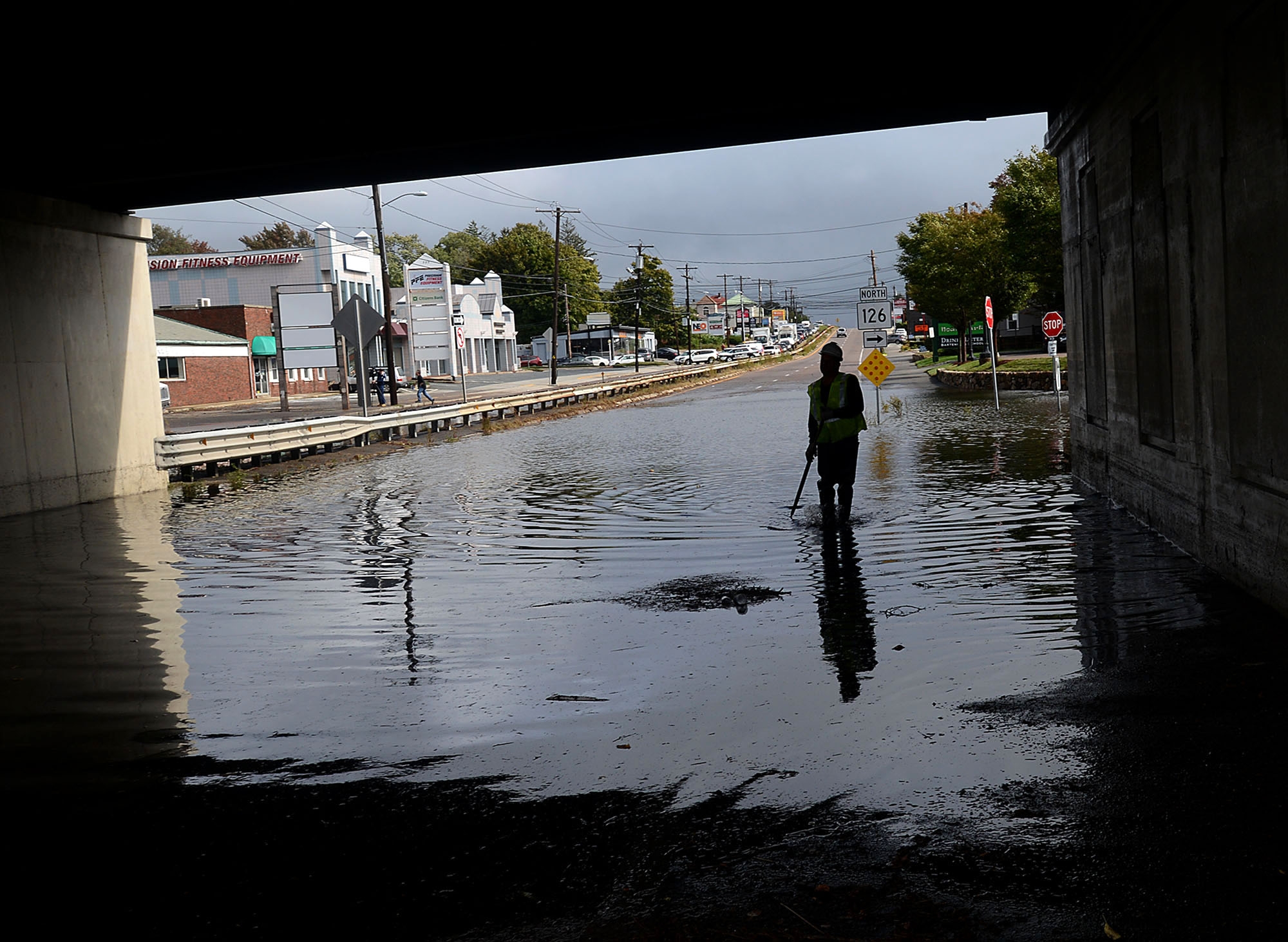
Major trouble spots include the intersection of routes 9 and 126, Walnut Street, the Hemenway neighborhood, Auburn Street and Circle Drive, Reed said.
According to Framingham’s 2017 hazard mitigation plan, a strategic document towns and cities have developed over the past two decades to prepare for natural disasters, Framingham has had more than 15 major floods since 1987.
The best way to stem runoff is to increase open space, but that would be challenging since the city is so built up, she said. Instead, the city is working to retrofit its infrastructure. The city recently applied for a $207,000 grant to fund a flood mitigation study for the Walnut Street neighborhood.
The city is also working with other communities to help solve problems that go beyond city and town borders.
The Wayland flood study recommends town officials keep flooding in mind when designing new bridges. The town should create posters and handouts for people living on property that could flood, but are not in a Federal Emergency Management Agency flood zone.
One of the major findings of the study, which Wayland conducted with the Metropolitan Area Planning Council, is for the town to work with the Massachusetts Water Resources Authority and the city of Framingham, both of which own dams just upstream from Wayland’s stretch of the Sudbury River. During the 2010 rainstorms, both the MWRA and Framingham released water from their dams, which flowed downstream to Wayland. The MWRA owns and operates the Sudbury Reservoir dam and the Foss Reservoir dam. Framingham operates the Saxonville dam.
“This is not just a Wayland issue,” McPherson said. “This is an issue that affects a lot of communities, so I think it’s really important that there be a high degree of coordination among some communities to try and lessen the impact of this.”